 Filter: Categories of Wisconsin Historical Images
Filter: COLLECTION_NAME of Maps, Reading Room
Filter: Categories of Wisconsin Historical Images
Filter: COLLECTION_NAME of Maps, Reading Room

| Date: | 1923 |
|---|---|
| Description: | Color map of the "Interborough Rapid Transit System of Greater New York". |

| Date: | 1923 |
|---|---|
| Description: | The back side of the map of the "Interborough Rapid Transit System of Greater New York". |
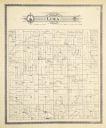
| Date: | 1896 |
|---|---|
| Description: | A plat map of the township of Lima in Pepin County. |

| Date: | 1899 |
|---|---|
| Description: | A plat map of Pleasant Springs in Dane County. |

| Date: | 1880 |
|---|---|
| Description: | A map of Milwaukee which includes a city street guide. |
| Date: | 1978 |
|---|---|
| Description: | A map showing allotments of American Indian tribes in Ottawa County, Oklahoma. On the left side is a listing of Lead & Zinc Mines. |
If you didn't find the material you searched for, our Library Reference Staff can help.
Call our reference desk at 608-264-6535 or email us at:

